Overlanders love them a good acronym. They also love em some good maps, along with Ham radios, Toyota “trucks”, and ignoring payload capacities. Okay, I promise that’s the only jabs I take at overlanding in this post.
Much like the hardest of Overlanders (lol, okay I quit), I love me a good map, too. As I’m typing this, I have 12 phone apps that have some sort of map capability. Paper maps are also a necessity, and are a cool souvenir of past adventures (and have saved my butt more often than I’ll admit). I nerd out on maps because they’re a good way for me to disconnect from whatever daily life task I need a break from. It feels like a direct connection to whatever place you wish you were, instead of editing formulas in the spreadsheet you’re overdue on.
Back to acronyms: MVUM. What’s that stand for? Motor Vehicle Use Maps, specifically those provided by the US Forest Service (and others). Although Public Lands technically belong to all of us, we can’t just go out there all willy-nilly whenever and wherever. That’s where the MVUMs come into play.
Each National Forest has it’s on set of MVUMs, and each district has its own respective map(s). These maps give most of the information you need to understand what roads are open to travel, what category of road it is, what type of vehicle is permitted on that road, and what dates that road is open for its designated use.
Let’s take a look at an example from the legend for the Daniel Boone National Forest’s Cumberland District:
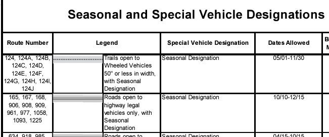
As you can see, the trails listed above have their own requirements for type of vehicle and also the dates those vehicles are allowed to access that Route. Habitat recovery, hunting access, construction and maintenance all factor into those Seasonal Designations. Not all Routes are seasonal, and you’ll also see that within the Designations.
Pay attention to the Special Vehicle Designations. MVUMs aren’t just for the road legal crowd, they also include Motorcycle Only singletrack trails (road legal and not), ATV/OHV designations for those not legal on highways, there’s High Clearance Vehicle designations for very rough roads, and several others. You might spot a County Road on a Google Map that could lead you to believe it’s a leisurely backroad from a country song. If you’re within a Forest Service Boundary, always check that County Road against the MVUM as it might be an “Unimproved County Road” that’s not maintained and not passable by most vehicles.
Shaded Areas on the map show the National Forest land, which means keep off the white/unshaded areas that are private or other property. Rules and Regulations, Contact Information, and other general land use information is found on these maps.
MVUMs are available hard copy at the District Offices across the National Forest. However, I want to point out the online printable PDF format. Not only is this convenient, this is important if you’re not planning on visiting the Welcome Center or Ranger Office during your trip.
I mentioned above that MVUMs provide you with most of the important information you need to plan a trip. Construction and Maintenance, Natural Disasters (Flooding and Forest Fires being regular occurrences), Seasonal Hunting Access, Habitat Restoration, and other things regularly impact access to Routes and Areas. Please always check the Alerts & Warnings tab on the Ranger District’s website where you get the online Motor Vehicle Use Map, or call ahead or ask in person.
It is worth noting that USFS MVUMs are available on most of the popular GPS phone applications and websites. However, like everything, please always go directly to the source for the latest updates. No matter how good those apps and sites are, it is a tall task to expect live updates to reflect fully and accurately on a third party source. That being said, it is a very good practice to utilize those maps within your app of choice, which will be another post for another day.
So, with all of that information above, see the links below to some of the District MVUM web pages for those areas near my neck of the woods. As always, Recreate Responsibly.
Daniel Boone National Forest MVUMs
Cherokee National Forest MVUMs (near bottom of page)
George Washington & Jefferson National Forest MVUMs
This is an Interactive Visitor Map from the USFS that can be filtered by activity (Road Legal, OHV > 50”, OHV < 50”, Dirt Bike, etc.): https://www.fs.usda.gov/ivm/